Our Wildfire Experience--2017
On the evening of Sunday, Oct. 8th, 2017, we attended a wonderful musical performance, to benefit the Museum, given by pianist Ian Scarfe at the beautiful new home of Bob and Rori Smith on Castle Road in eastern Sonoma.
It was quite windy as we drove home to our small pied-a-terre apartment on W. Spain Street known as The Hütte, not wishing to drive north to our house in Glen Ellen, and went to bed around eleven, hearing a few sirens headed down the street. I woke up around three (not unusual for me) and smelled smoke. I poked my nose out the door, and smelled more. I jumped on the internet, and learned there were fires in Calistoga and Santa Rosa, and in the Mayacamas hills above Glen Ellen.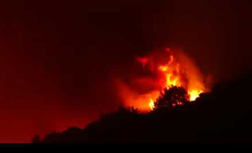
I threw on some clothes, and jumped into my pickup and headed north on Highway 12. The air was thick with smoke, the streetlights dim and hazy. At Boyes Springs, the traffic light was out, and I could see that streetlights to the north were out. At Madrone road there was a CHP roadblock, so I headed west on Madrone and north on Arnold. It was around 4:00 am. There was no roadblock all the way into Glen Ellen, but there was a roadblock at Warm Springs Road (the route to our house on Sonoma Mountain) and on the Highway at Arnold Drive, both north and south. I pulled over at the intersection, and saw the hill just above Quarryhill
  Above QuarryhillBotanical Garden roaring with what looked like 100-foot flames. There was fire looking southeast, where Glen Oaks Ranch sits, and I thought that the Sonoma Land Trust’s historic stone barn and stone house, as well as the ranch house that is home to John McCaull must be either gone, or in grave danger.
I could see houses on fire out Dunbar road, trees on fire at the George and Karen’s house on Arnold, and climbing the slight rise to the gate of our friend Yvonne’s old house next door, saw a wall of flame. The hill behind had fire creeping down it, the top burned out, and my heart dropped as I knew that just over that hill were the homes of many of our friends on Wolf Run.
 I headed back down Arnold to London Ranch Rd, and saw a house on fire just up the road. It was roadblocked, as was Hill Road, up which I saw more fire. There were cars in the parking lot of the Glen Ellen Market, and people were gathered trading stories and speculating. It was getting light, and I drove back south, past the Grist Mill complex, which was intact, but saw in the growing light that most if not all of the Sonoma Regional Park had burned – it was black and smoking.
I turned back up-valley, and found that the roadblock at London Ranch Road was gone, so I turned left, and drove past smoking fence posts and burned fields and trees to Benziger Winery. The gate was open, and wind-blown tree debris littered the road, but no signs of fire there. Looping into the winery, it was extremely eerie – no sounds, as no power. No people. The air thick with smoke as yellowish daylight blossomed. Our house on Sonoma Mountain Road is normally visible across the Graham Creek valley from the winery, but the smoke was so thick I could only see the outline of the redwood grove and oak trees. But nothing looked black in the amber light. I walked out into the vineyard to the farthest point, but even with binoculars could not make out whether the house was there, or gone.
Back down to Sonoma around 6:30, where looking east on Spain Street, there were towers of thick smoke, and  the same looking north toward the hills above town. Troy was still asleep, having no idea of what was happening, so I woke her and told her about all the devastation, and that there was a possibility that we no longer had a home. I got back on the internet, and with some Googling around found the MODIS and VIIRS fire-mapping overlays in Google Earth, and set about learning the different modes, and how to read them. Nasa’s satellites Aqua and Terra take spectroradiometer readings from space and translate them into useable fire location and intensity data, which the USDA Forest Service turns into overlays in Google Earth. It was clear that this was a huge and horrendous set of fires across Sonoma County.
I received texts from our oldest friends, Ken and Diane, who live on Wolf Run, and their neighbors Tim and Joshua, and learned that they had been forced by the Sherriff to evacuate around 2:30, having watched the fires blossom and rage from their deck, which has an expansive view of the Mayacamas range. They had all gone to David and Mandy’s house in the south part of Glen Ellen, until the Sherriff again forced evacuation there, and then went to our friend Joyce’s condo on First St W in Sonoma, two blocks from the Hütte. We learned that Sherriff’s emergency updates were being texted by something called Nixle, and began learning about road closures and evacuations, advisory and mandatory.
We rendezvoused with friends and fellow evacuees at Joyce’s condo to compare notes: learned that Dennis and Anne had evacuated to friends in Inverness; Val and Tripp (more Wolf Runners) had checked in, being due back in a couple of days from a vacation, and were advised of events, and roadblocks locking out Glen Ellen. That evening we gathered for the first of two weeks worth of DPCD—Displaced Persons Communal Dinners—in Joyce’s condo. Sorely needed cocktails, spaghetti Bolognese, salad and ice cream. In spite of news everywhere, and the MODIS fire maps, none of us from Glen Ellen knew if our houses stood or were gone. Joshua, Tim, Ken and I decided to drive north and see if we could get through, despite Glen Ellen now being a legal mandatory evacuation area. CHP roadblock at Madrone on the highway, full road closure on Arnold, but without cops. As we approached, considering driving past, both Tim’s and my phone pinged at 8:09 pm with a Nixle alert stating “Unlawful entry into evacuation zones. There is no tolerance for anyone entering these zones and violators will be arrested.”—big brother was watching us—on which sober note we turned around to go and try and find sleep.
Which was very elusive. Up and down all night, browsing the internet for information, refreshing the MODIS fire maps – pretty amazing technology, which delineates location of detected fires by time frame, color-codes the time frame so you can see the “aging” and movement of fires, and in a separate view color codes the FRP—fire radiative power, which indicates the intensity and heat.
Early Tuesday there was an alert for evacuation of Roberts, Lichau and Pressley Roads – over the backside of Sonoma Mountain from the house, and, ominously, for Sonoma Mountain Road. SMR loops from Bennett Valley Road (into which Pressley ties) around down past our house to Warm Springs Road, which leads another mile and a half into Glen Ellen. We were now officially evacuated and banned from the house.
 Regional ParkAround seven am I headed north again, to find the roadblock at Madrone strengthened to “hard closure” and to find another roadblock on Arnold at Madrone, but no cops. I scooted by, and then saw cops at the bridge at Eldridge. Turned south again. Looking at Google maps, I spied a possible way through: went through an open gate in Rich Little Vineyards, wound through vineyard roads, out BR Cohn’s driveway to the highway and headed north. Just north of Cohn vineyards where the east portion of the Eldridge--SDC complex lies, the hillside was completely blackened. Most of Bouverie Preserve to the east was burned, but it
  Bouverie Preserveappeared that MFK Fisher’s Last House was standing. As I passed the Cal Fire station, there were at least 50 fire trucks of all colors parked on the roadside, exhausted firefighters taking breaks. All of the Regional Park was a cinder, and the beautiful new barn at Flatbed Farms was completely gone, still smoking, save the crumpled metal roof. To the east again, I could see through charred trees that the stone barn at Glen Oaks was indeed torched, just the blackened stone walls precariously standing.
Approaching the curve where Arnold Drive intersects the highway, I could see the major roadblock, and, leery of being 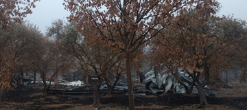 Flatbed Farmshad up for sneaking past the southern roadblock and entering an evacuation zone, I turned around and re-traced my circuitous route out to Madrone. I went north on Arnold again, and found the cops at the bridge gone, and was able to get into Glen Ellen. I headed out Warm Springs, finding blackened devastation on both sides—just mind-numbing.
  Warm Springs RoadA half mile in, there were power lines hanging, arcing and sparking, and I said “that’s it – no further”. No roadblock on Dunbar, so drove out that road a way, past blackened trees and fields. At Lasseter’s house, the smoke was thick enough not to be able to see if the house was gone, but there was a
  Dunbar Roadburning fire in front of it, and to the other side of the road, a fully flame-engulfed house – no fire fighters around—higher priorities elsewhere. That was enough of that as well, so I drove back south to on Arnold.
I got a stomach-dropping phone call from Diane--she had received a call from Betsy Phillips, who with husband AG lived at the top of hill on Wolf Run, saying that their house and Ken and Diane’s were gone--"it blew up at 3 am Monday morning"--less than a half-hour after they evacuated, but that the rest of Wolf Run was standing. AG Phillips and son Josh had stayed attempting to fight the fire, but as it crested the ridge behind them, up from Glen Ellen, it was a true firestorm—I had seen the last of it early Monday morning burning down the hillside above Glen Ellen. It’s hard to describe the feeling of shock and horror—learning that your oldest friends’ house and worldly possessions had vaporized.
Heading south, I made the first of many very long roundabout slogs—down Arnold, out Stage Gulch, northwest on Adobe, north on Petaluma Hill, east on Roberts to Pressley, winding up past some burn zones to find the CHP at SMR. There were two cars ahead of me. I saw the Chippie let the first fellow through. I heard the conversation with the second fellow, as he was turned away, and heard that the first fellow was let through because he had to retrieve critical medication. When my turn came, I stated truthfully that I had to retrieve blood pressure medication, and was let through. It was again eerie winding through the smoke up a deserted road, stomach churning seeing smoke pouring off the whole of Sugarloaf Ridge and Hood Mountain from the crest of the road, but through uncharred fall foliage around the twists and turns to reach our driveway and find the house untouched, nothing burnt anywhere around, and all very quiet save for birdsong and quail rustling in the brush.
I checked the house—power out, heavy smell of smoke throughout. No water with well-pump gone, and no irrigation, so the landscape would suffer. Benziger Winery was faintly visible across the creek valley in the haze. I decided not to remove any valuables, as it seemed at that moment like the danger was mostly passed. I went to try and check on friends’ houses—Warm Springs Road was blocked at the bottom of Sonoma Mountain, so no access to Wolf Run or Glen Ellen. Tim and Susan were at the intersection, and said Joshua had talked his way Wolf Runpast the roadblock, and he and the other Susan were up checking Wolf Run. We waited for them to come back, and
 photo: Josh Rymer Joshua confirmed their house and Anne and Dennis’s were standing, with charred woodland right up to the houses--the fire was apparently a raging firestorm as it raced up the hill from Glen Ellen and consumed Ken and Diane's and AG and Betsy's homes, but calmed as it moved down the ridge toward the rest of Wolf Run.
Back up the hill, I turned north on Enterprise Road. The fire maps had shown that part of Enterprise had burned. I could see that the Harvey and Deborah’s house was standing with no burn nearby, as was Betsy and Tom’s and Bill and Laurie’s. Further out on my way to check on Cris and Lorna’s property, I saw two trucks parked at the side road, and Cris was standing there in part of a group. He said that he and Sal, his vineyard manager who lived in a house on property, were preparing to “move out”—there was active fire moving up Bennett Valley, and a fire truck a half-mile out Enterprise preparing to engage. That was further sobering, so I returned to the house, and spent an hour loading our most valuable art, Troy’s jewelry from the safe, and passports, insurance and other important papers.
I headed back up SMR, and found traffic stoppage—one-way—and two fire engines and a crew a bit east of Mountain Meadow Lane. As the opposing traffic cleared and I inched up, the fellow on the engine said I could proceed, and when I asked if they were backfiring, he said no this was the fireline front, and the were determined to stop it from going further up the mountain, or eastward on SMR. They were successful in the end, which may have been the ultimate salvation of our house and others. I travelled back to Sonoma and unloaded everything into the Hütte. The day was a haze after that.
I went to the market and bought supplies for dinner. We got out the table extender, and the ten DP’s partook again of strong drink, and crowded in to dine on salad, mixed-pepper chicken stew and apple gallette, all cooked in the Hütte’s tiny one-butt kitchen. I checked the fire maps, and saw new fires on Sonoma Mountain not 2-3 miles from our house, and moving east and south. Ken and Diane were shell-shocked but trying to keep up a good face. They had been out to buy basics of underwear, shorts, a tee shirt, a blouse. They had nothing left but the clothes on their back as they had driven away at 2:30 a.m. Monday. And their lives, of course—by then the county death count was over a dozen. We were grieving for them, but also, with the fire map updates, were worried sick and thinking that by morning we would be in the same shape they were.
 By Wednesday morning it didn’t look like the fire had moved as far as our house. The MODIS fire zones were “aging out” on the maps. I made my usual rounds again to see if getting into Glen Ellen from the south was possible, and then made the drudge drive around the back way. Joshua called and said they were heading around the back way to try and get in. I told him about the medicine excuse for entry—I was 45 minutes ahead of him, and told him to stop at my house on the way, and I’d come and give them a hand. The roadblock was still at Pressley, with a different CHP. I used the same excuse, and was asked to prove address with ID, which I did, and was passed through. There was now a roadblock at Enterprise, preventing any entry into that area. I checked the house, used a bucket to dip water from the pool and water some potted and wilting plants, brought the garbage bin up to the front door, and threw out the fridge and freezer, which had now been without power for three days.
Joshua and Tim stopped, and I followed them down the hill and up Wolf Run—no roadblock that morning. Even eerier: black, burnt, smoking stumps, burned trees cut and moved off the road, and the thickest smell of smoke and burn yet. The fire had burned right up to the edge of their house and landscaping—looked like it had burned down from the ridge. We threw out their fridges, and then went up to check Anne and Dennis and Val and Tripp’s houses. We fed Anne’s cats, which they had not been able to find at evacuation time. Same story—burned all around, but the houses stood. No sign of firefighting activity, and a notice on two houses seeming to indicate that the firefighters had declined to try and protect the houses. However, at Tripp and Vals, there was a differently worded notice, abandoned houses around, and a firebreak below the pool that had clearly been cut by a dozer. Tripp and Val were headed in from the coast, so Joshua decided to wait for them, but Tim decided to leave with me.
The roadblock mysteriously and temporarily gone, we drove slowly out Warm Springs, to learn that the Wolf Run fire had apparently burned up and over the back Glen Ellen ridge – the area just south of Wolf Run and around the hairpin was untouched. A hundred yards further, evidence of blackened trees and power poles appeared, and from there on out to Glen Ellen, all but a small handful of houses on both sides of the road were completely burned to the ground—power poles burned through at the bottom, and wires and  Warm Springs Roadtransformers sagging. Back down through Glen Ellen, again past the horrendous blackened wasteland of the Sonoma Regional Park—wondering when and if we would ever walk through the lovely oak forest listening to the acorn woodpecker’s chatter.
 SDC
SDC
That afternoon, I drove east on MacArthur Blvd. to the closure at 8th St E where a crowd had gathered looking north across a vacant field to the smoke rising above the low ridge where fires had come down from Lovall Valley and into the lower Ranch. Air support had finally arrived in the valley, and two choppers were dipping buckets in vineyard reservoirs and dropping 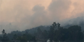 them serially on the ridge fire. That afternoon a red and white 747 supertanker shuttling back and forth from Sacramento dropped a mile long stream of 18,000 gallons of retardant on the fires above Sonoma. We would later learn it’s the only one in the world, and is dubbed the Spirit of John Muir. The Norrbom fire to the north was continuing to billow smoke into the air, but didn’t look as if it was moving closer to town.
An evacuation center was established at the Sonoma Valley High School, and Troy went over to see about helping out as a volunteer. Cots everywhere. Herat-tugging barely controlled chaos. Former NFL star Tony Moll oversaw distribution of hundreds of pizzas to evacuees and firefighters alike. Friend and Glen Ellen neighbor Holly joined the crew of Tri-Tips Trolley building hundreds of burritos, two-handed, she reported, and drove around the valley with them in a cooler, distributing them to firefighting crews. Food was similarly coming nonstop from the kitchen at the Fig's Suite D kitchen for delivery to the firelines.
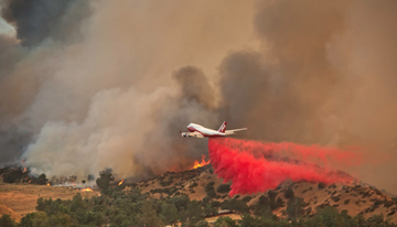 Photo: Wildfire Today
At 8 pm Wednesday, as some of the DP’s were tucked into the just re-opened Red Grape for pizza, ravioli, salad and burgers, after downing nerve-deadening cocktails at Joyce’s condo, phones bleeped: mandatory evacuation for Lovall Valley, Castle Rd, and 7th St E. was just announced, as well as an advisory evacuation for Sonoma City north of Napa Street, which included the Hütte. As we arrived back there around 9, our neighbor to the rear, Mike was again hosing down his shake roof with a high-powered spray. I took the smaller front hose and hosed down the roof of the two-story Hütte (circa 1885) which has a composition roof, and thus less prone to embers catching. His house and the Hütte sit in a large field to the west and north, which provides line of sight to the hills, and grass-only protection for a good way out. Mike said he was leaving only when he saw the fire coming down the hills above town.
Fitful sleep again, up and down to check internet, fire maps and worry.
Thursday morning I made the long drive around the back to check on the house, but found the roadblock moved out on Pressley Rd to Lichau, and an impassive officer who would accept no excuse to get through – citing lots of PGE trucks along the road. He said he’d heard that block might be lifted later in the day, so l returned to Sonoma.
At 11 am Thursday the mandatory evacuation zone for east Sonoma was moved in to 4th St E, so could no longer get out MacArthur for a view north. Looking directly east on Spain Street it was plain to see smoke continuing to tower in the eastern hills. We were concerned for friends who lived on Castle, North Castle, and up Lovall Valley, but with no real way to connect.
I headed out and around again, and got through the Pressley roadblock with ID in the afternoon. Blackened areas were now visible directly adjacent to Sonoma Mountain Road near its top around Mountain Meadow Road, where that crew had stopped it. The fire maps showed extensive burns between there and Bennett Valley Road, coming part way in Enterprise Road. House still ok, bucket-watered plants (that’s a lot of work) and loaded up a few pieces of heavy sculpture, and a few more paintings. Went down to the bottom of the hill to check for access out through Glen Ellen – no joy. I made my way back the grueling roundabout route to smoky Sonoma.
 Sonoma Day FourBack in town, Sonoma seemed very deserted. Almost no cars parked on the plaza save around the Basque Boulangerie, which stayed open, and Steiner’s bar, which seemed the place for exchanging news, sharing stories and downing cocktails for many. West Spain—usually packed and a hard place to find parking was virtually empty. Stores, markets and restaurants were mostly closed, with a few open sporadic hours. Safeway stayed open 24/7 and cleaned up when other markets closed early or didn’t open. Thursday night the DP’s gathered again back at Joyce’s for leftover Bolognese and salad. As we were pouring cocktails, Joyce’s niece Kerry bounded up the stairs, and said that her friend and City councilwoman Amy Harrington had just arrived at Kerry’s for dinner, and said she had talked with Cal Fire, and they stated that Sonoma City was safe for the night: there would not be mandatory evacuation.
 photo: Ken WornickFriday the air in town was again very dense and smoke-filled, with a mushroom cloud billowing up to the north and east. It was sometime on Friday that the Nun’s, Norrbom and Lovall fires all merged into one huge crescent surrounding Sonoma. I didn’t make the long trek out and around to the house. Tried both northbound routes—Highway 12 and Arnold Drive, but still embargoed. Sonoma city even further deserted. Friday night the DP’s moved to Yvonne’s house in nearby Park Villas, for martinis and cashews, roast chicken and salad, and mucho vino.
Later Friday night (Saturday morning, in reality) I woke around 2:30 am and within minutes, Mike was pounding on the door saying, “it’s coming in fast – one of my buddies on the police scanner says it’s at Arnold Field—load up and get ready to move out.” I went out front, and the eastern sky above rooftops was glowing red, the smoke thick. I woke Troy, and called Yvonne, alone in Park Villas down the street—she didn’t answer the phone, so I sped over in the truck and pounded on her door til she woke, and told her to re-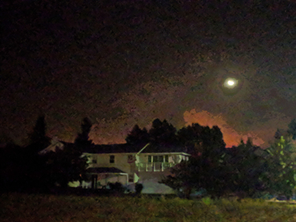 Looking East Saturday Day 6 3 a.ms pack the car and get Sophie the cat ready to go (not a fun prospect as she hates car travel). Back at the Hütte, we furiously loaded clothes, medicine, and the valuables once again into the truck and the Smart Car. Mike hosed his house again, and I hosed the front. He came back and said the Arnold Field report was false. The fireline was at the far end of Castle road (where we had been for the musical event literally at the same time the Nun's fire was starting), burning houses there, and was burning up 7th St into the Ranch. The shriek of sirens filled the air. Phalanxes of fire trucks sped east: from Petaluma, Two Rock, Merced, Madera, Fresno, Atwater, San Rafael, Santa Barbara, and more. They were making a stand to save the town of Sonoma. We learned the next morning at the 4th St roadblock that there were 80-plus engines, four massive bulldozers and 500 or more firefighters keeping the fire from reaching town.
No mandatory evacuation orders came. We sat around dazed, as the clock ticked by, going in and out checking the look of the sky—it flared and brightened, and dulled again, several times. Troy went back to bed. At about 6, Yvonne took Sophie home. We watched the 6 am news at her house, and the Sonoma fire was live and front page, showing the burning houses on Castle. I went home to catch a couple hours sleep, and Yvonne called later to say she was evacuating for a few days to a friend’s in Tiburon for some stress relief and clearer air. The DP’s at Joyce’s had been up most of the night too, watching the glow and glare from Joyce’s upper decks.
Saturday morning the Sonoma Index Tribune website headline was a photo of Ledson Winery, northwest of Kenwood, with billowing smoke and blazing flames rising right behind it. Rumor (un-confirmed) had it that PGE had re-energized a portion of the grid around Pythian road—without on-site verifying that there were any lines down—and there was a line down—which arced and started a new fire, that grew quickly into an epic conflagration. This was of course worrisome as if the winds came up from the east, it could be blown west across the highway and make it’s way toward Sonoma Mountain. Monitoring of the news and fire maps over the course of the day brought relief that the crews kept it from coming westward, and, without NE winds, the natural course of fire—uphill—took it eastward, creeping over the Mayacamas toward the Napa county line.
We unloaded the vehicles of valuables and clothes again—the third time? fourth?
I circled the eastern checkpoints trying to get information, but they were almost always manned by out-of-town officers, who rarely had any actual information. One did know that they were still battling the Castle Road portion, but that the fire so far had been successfully stopped from getting into the town.
Troy and I went to the Girl and the Fig, newly re-opened, for lunch, which was virtually deserted. Just a few people sitting at the bar, including VOM Magazine editor David Bolling and his daughter Olivia, who had been roaming the Valley ceaselessly—able to pass roadblocks with press credentials, getting information and taking photos. All spoke of nothing but the fires, of course. The outside world didn’t exist. Trump who? What baseball?
I tried going north into Glen Ellen again (fruitless, I knew in advance) and was turned away. I headed south and around the long way, got through the Pressley roadblock and wound up and over toward the house. At the crest of the road, the view northwest was again frightening. The new fire flared last night up Pythian Road, was burining north in the Mayacamas, and threatened to cross the highway westward, which could again put our area in danger.  Smoke over Mayacamas Adobe Fire SectionAt the Enterprise intersection the roadblock was now national guard, with soldiers in camo, and camo Humvees with machine guns mounted on top! Serious roadblock. Run the CHP roadblock, and they chase and arrest you. Run the army roadblock and they gun you down!
By Saturday night, it seemed pretty certain that the fires would not get into the city limits of Sonoma, though certainly several houses in the surrounding hills had been destroyed, more damaged, and many a very close call, with vegetation and trees burned very close. Sunday we had the DP’s for lunch at the Hutte, and tried to move away from “fire eating” toward more healthy diet with salad nicoise and rose wine. The town of Sonoma seemed safe, but the level of destruction and devastation elsewhere around the county was simply awesome, and the fires in the Mayacamas and elsewhere were still burning.
Epilogue—Monday, October 30
I continued to get in and out to the house the long way around every other day or so for the week of October 16th, as we remained evacuated in Sonoma.
The DP’s in shifting contingents continued to dine communally that week, clustering for comfort and solace.
Sonoma residents gradually returned, and the streets slowly filled with cars and people. Restaurants and shops gradually re-opened, and some tourists in limited numbers wandered in.
Power was restored to our house on Sonoma Mountain on Thursday, Oct 19th
Saturday Oct 21st Glen Ellen was finally opened to through traffic—one of the last evacuation re-openings in the county, but the blackened and devastated Warm Springs Road area was still closed—access to our house only up and around Highway 12 through Kenwood.
Sunday Oct 22nd Warm Springs Road was opened to residents with ID northbound – but to return back to Sonoma, we still had to go north through Kenwood and down Highway 12.
Tuesday Oct 24th the Warm Springs Road roadblock was finally lifted, and traffic was normal to access the house as usual—with the gristly reminder every time of the ruin around.
As of today, Monday, Oct 30th, there is still no phone or Internet service in Glen Ellen, and even with a phalanx of at least eight PGE cherry-picker trucks along Warm Springs Road today, re-stringing line, the on-site workers estimate it will be weeks before telephone and internet service is restored.
Full containment of the fires officially came Oct 31st, after 23 days of intense firefighting on multiple fronts.
A Few Aftermath Photos
 Lovall Valley
 The Ranch
 East of Glen Ellen
 Wood Valley Rd
 Sonoma Valley Regional Park
Warm Springs Rd - Glen Ellen  Sylvia Rd-Glen Ellen
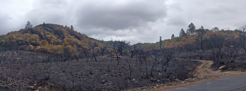
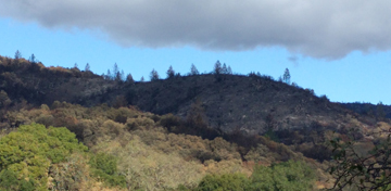
 The blackened Mayacamas from our kitchen window view
Statistics
The combination of Wine Country fires is deemed the largest single natural disaster in California’s history.
Over 110,000 acres of Sonoma County—in excess of 10% of the second largest county in California—burned.
An estimated 6,600 structures including 5,130 homes destroyed in the county; an estimated 453 houses lost in Sonoma Valley, with 183 houses and 453 total structures in Glen Ellen alone.
Virtually all of the Sonoma Valley Regional Park in Glen Ellen burned; over 80% of Sugarloaf Ridge State Park and more than 60% of Hood Mountain Regional Park burned. The view of those mountainsides from our kitchen dining area from left to right are a sweep of black.
Estimated total County-wide damage is over $3 billion, and climbing.
23 confirmed deaths, mostly very elderly people, with many people still unaccounted for.
Several close personal friends lost their homes, and everything in the world that they owned.
The task of recovery and re-building is almost unfathomable.